
Starting at Tansley just off the A615 park at either the Tansley Tavern pub car park or on church street Tansley just the second right coming from Alfreton heading towards Matlock. Starting from the car park walk down the main road towards Matlock and take your second right onto Church street Tansley and walk up Church street until you turn left onto the road The Knoll follow the road around and to the end as you walk round you can see the woods up at the top of the hill and a single house called Oakedge farm. This is where you are heading towards, as you walk along the Knoll you pass a footpath labelled Lumsdale and this is the path you will return on and the walk can be done in reverse to shorten the walk and come out at the bottom of the waterfall you could turn left here and walk straight to the waterfall and bottom of the old mill.

As you get to the end of the Knoll you are provided with a choice of paths take the road around to your left over the river and walk up the hill and up Oakedge lane heading towards the farm house and the start of the woods.

At the top of the Lane turn right up into the woods there are two paths do not take the first one on your right but take the second one that goes straight upwards slightly further on . As you walk up the path you will pass an old Quarry on your right hand side used for quarrying mill stone, just after this take the path around to your left and notice how the path falls away to you left hand side and looking out you can see Riber Castle on a clear day.

Follow the path along the edge through the trees and after a while you are presented with two paths one sharply up on your right and another that crosses over a small wall and follows along a fence. Take the lower path along the fence line and follow to the end.
 |
Follow the path around to your left keeping the edge on you left side and views of Riber castle. Follow the path over the wall and along the fence line. As you get towards the end of this path a solid stone wall on your left bends round and a path joins you from your right hand side, follow the wall around to your left and in a short while the path forks into two take the path on your right and walk down the path to the river. As you start on the right hand path the land on your left that is fenced of is the UKs first landfill and remnants of glass bottles and tins are visible on the surface from looters looking for collectable glass bottles and tins. At the end of the path you will cross a small wooden bridge and turn left along Lumsdale road with High Field school on your right.  Follow the wall around to your left. 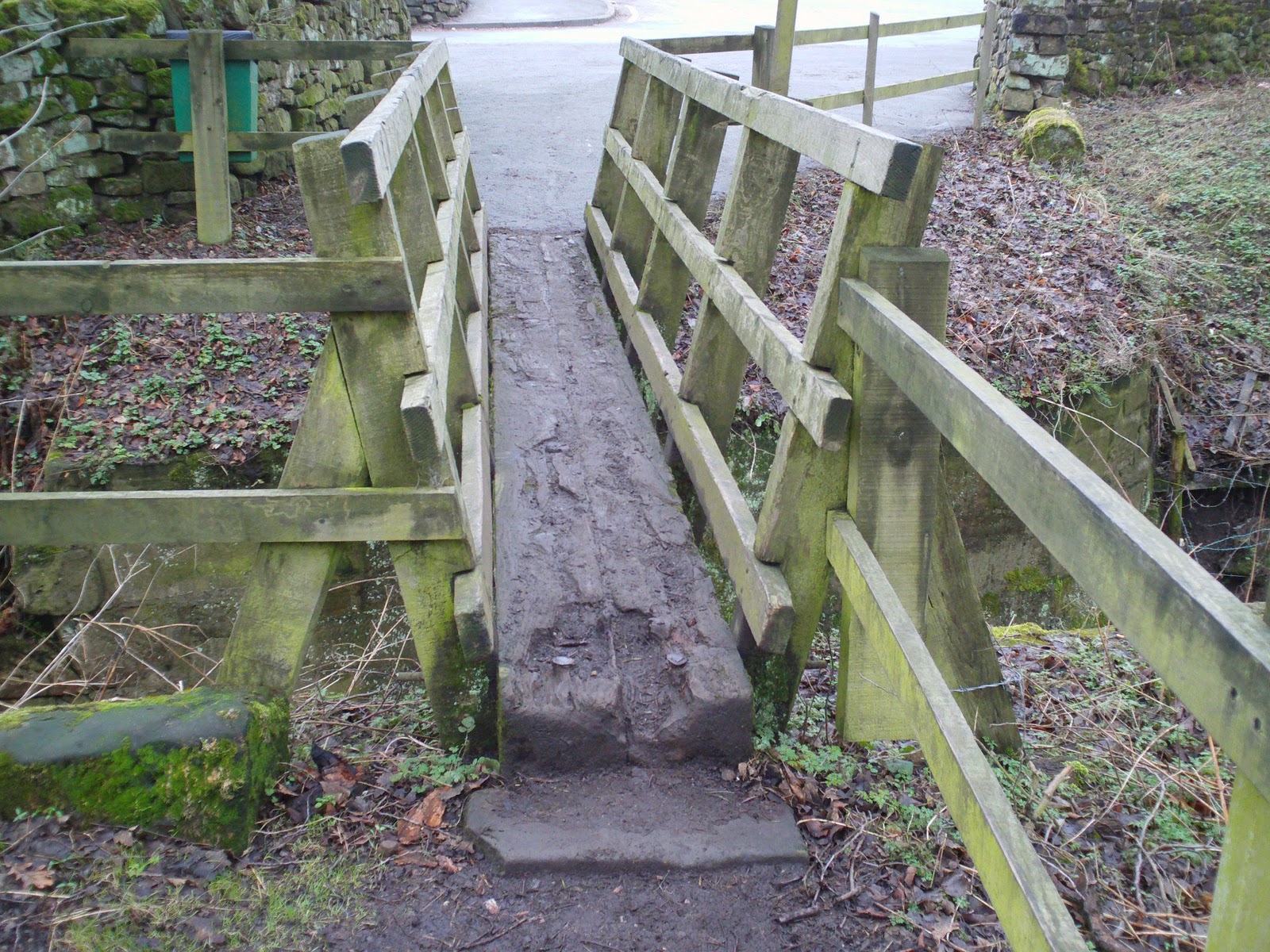 As you walk to your left you are going to follow the river all the way to the mill pond, walk along Lumsdale road or follow the river and pass some small old mill cottages once used by mill workers and the lane opens out on to the mill pond and the start of the waterfall.  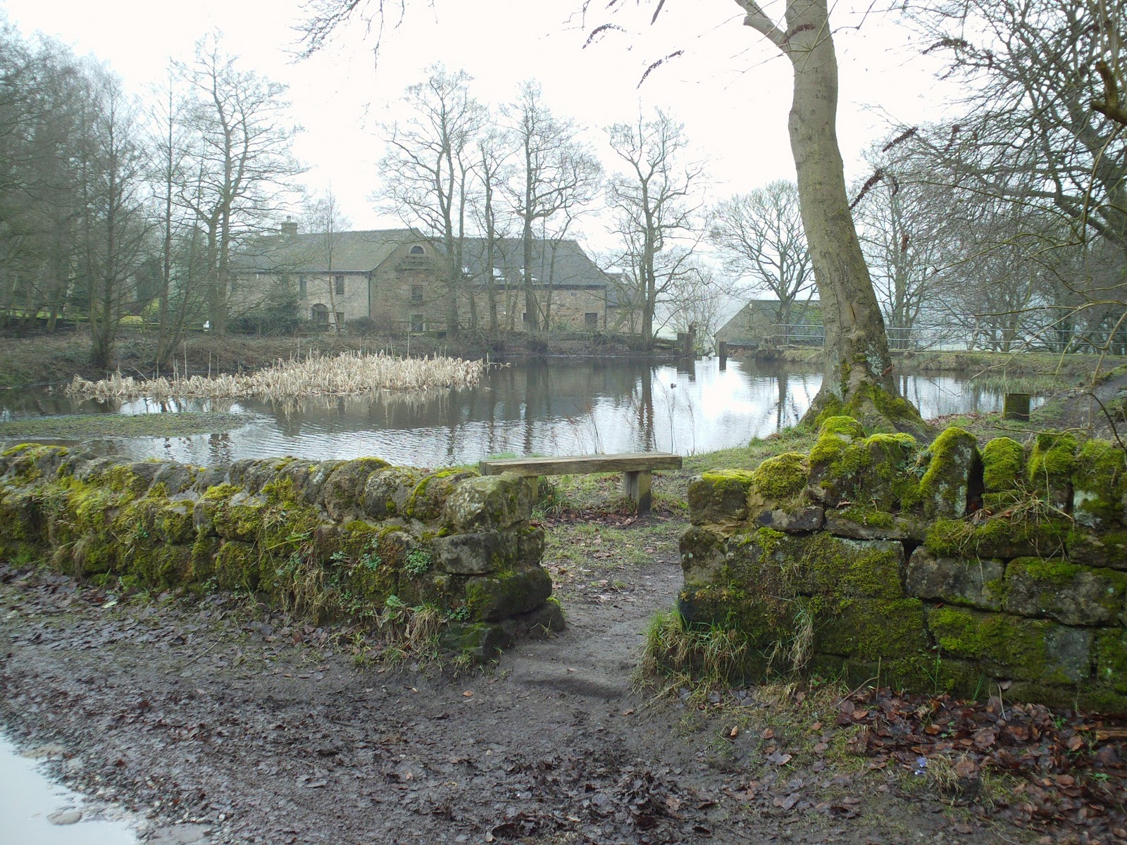 Continue to follow the river as it cascades down the face through a route of manmade mill wheels and small natural waterfalls and look at the warren of buildings and tunnels used to power the mill using natures natural resources. The mill has been restored by the Arkwrights trust and provides stunning backdrops and during winter is popular with photographers taking iced waterfall photos. At the bottom of the path you join back on to the main road Lumsdale and follow the road to your left. 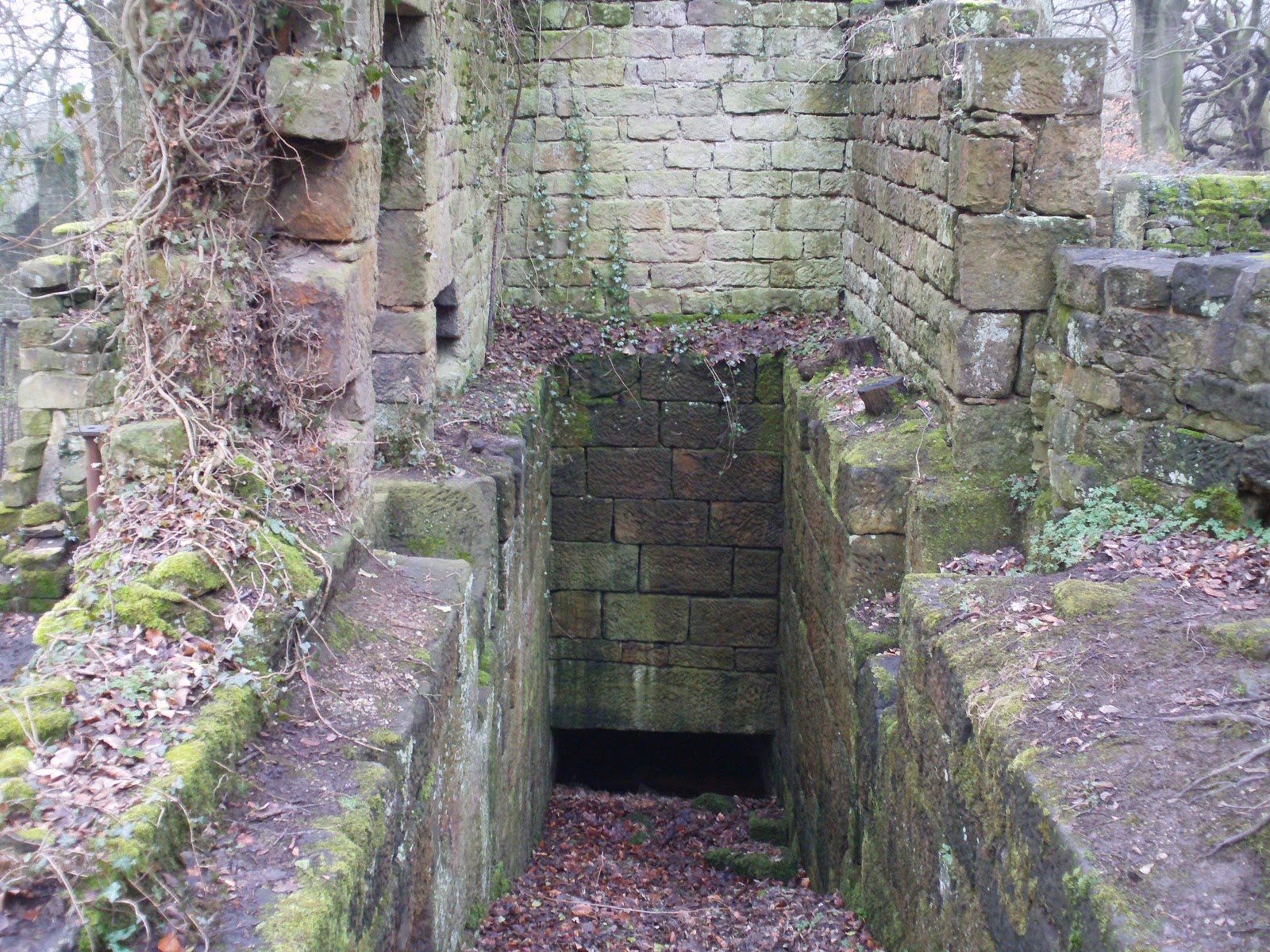 The housing for one of the mill wheels and visible the exit route for the water to be redirected back to the river.             At the main road Lumsdale turn to your left and follow the road past the bend with a footpath on your left and another footpath on your right across the road and over the river that takes you back up to the A615. The other path on your left takes you back towards Oakedge lane. However follow the road along and past the Old pottery barn and the road bends sharply to your right back towards Matlock. On the bend on your left side is a small metal gate and a well established footpath which again follows the river, take this path and follow to the end.  At the end of the path you come out at the Tansley Scout Hut and cross the river over a little bridge and under an arch way of trees heading back up the Old Coach road. As soon as you pass the arch way turn up the path on your left and walk up the wooden steps standing at the foot of a small fishing pond.   Follow the path around the pond to your left and continue through the trees straight on and eventually uphill back to the Knoll.  From the top of this path you are back at the start and you are standing on The Knoll where you first started and depending on where you parked it is a short double up back to the car park and as first stated if you only want to see the Old mill and waterfall it is a much smaller walk to turn down this path. It is also possible to drive through Lumsdale and park at the bottom of the Mill in a small lay-by. This is a small walk and enjoyable walking from the woods taking in the higher view points and walking back down watching the river cascade and open up in front of you with little warning. The walk its self can easily be walked in three hours and much quicker for the more serious walker, but there are many options for the more serious walker to extend the walk up over Riber and back through Matlock along High Tor. As this is a short walk it is suitable for taking the family and Matlock baths is just round the corner to visit for a fish and chips dinner and enjoy the attractions on offer.    Enjoy !! |
Thanks for the info - it's much appreciated.
ReplyDeleteI will paying a visit to Lumsdale this week-end and your blog has been very handy.
Cheers
Inspiring! Thanks for the effort! Will be walkin this one Very soon!
ReplyDeleteGreat stuff... Cheers mate.
ReplyDeleteI came here once as a child....its lovely!
ReplyDeleteJust want to thankyou for the information on the walk. Just got back from doing it today. Managed to get some good photos of the falls. Been coming to this area for over 30 years and never new the falls were there.
ReplyDeleteGreat walk. Thank you for the info. We had a beautiful sunny day and the falls were their best after a few days rain. Just gorgeous.
ReplyDeleteWe did this walk yesterday absolutely brilliant! Thanks!
ReplyDeleteDid this walk last Friday, didn't even know that pond or falls were there. It was a nice sunny day, took the wrong path in the woods but turned out OK in the end, nice little walk, cheers
ReplyDeleteI love Lumsdale. Been there several times, and it never fails to perk me up. There's just something magical about the place. Thanks. Keep up the good work.
ReplyDeleteLooks fantastic. Any idea roughly how far the walk is ? I'd just like to make sure it's suitable lengthwise for the people we're taking there. Thanks.
ReplyDeleteSpectacular falls, better going bottom to top, I think. Rest of it just a countryside walk. Okay, but the falls are the attraction.
ReplyDeleteA lovely place to visit, not the easiest place to find though - it took me two attempts.
ReplyDeleteA lovely place to visit, not the easiest place to find though - it took me two attempts.
ReplyDeleteSo pleased we found this hidden gem, will definitely return in the summer minus wellies and raincoats.
ReplyDeleteWhat is the source of the river? Is it connected to the Derwent insome way? x
ReplyDeleteVery useful thanks. I copied out the text to take with me and did the walk today. A fascinating piece of hidden history. And it looks much nicer now there are leaves on the trees.
ReplyDeleteJust done this walk today very pleasant I'm not a walker but found it quite easy steep in places but there are steps and hand rails in places lived in the area fog 5 years didn't even know it existed 09/08/16
ReplyDeleteHi how many miles is this walk please
ReplyDeleteHi Thanks. It was the perfect walk for our family, 2 girls 4 and 6, parents and grandma. A bit of everything: climbing in the wood, walking next to the stream with ponds, waterfalls and stepping stones, discovering the remains of the old mill.
ReplyDeletePS. I have seen another family with your printed drawn map...
Thanks for the suggestion.
We had a fab day doing this circle with our 12 yrs old daughter and our puppy .Was a bit steep at places but so lovely!! We parked at The Gate Inn and going down on rd ,turned up to left onto a steep road...so we went a long way around but finally we've found the river and then the waterfall...Thanks for your helpful blog!
ReplyDeleteErrr......mileage ideas? Thanks
ReplyDeleteWe have just returned from this delightful walk with our grandsons. We all loved it. There were lots of surprises along the way.a perfect walk. Thank you for your blog.
ReplyDeleteHi. Could you tell me how long the walk took? We’re planning on doing it next week with out 10 month old on our backs so hoping it’s about an hour?! Thanks
ReplyDeleteGreat description of a lovely walk, but please don't encourage people to drive down into the valley and park there. Parking for the falls is opposite the school at the top of the valley. The valley is being spoilt by the number of cars now driving down and trying to park. It's also a dangerous drive, it's single track, lots of blind bends and the road is frequently very slippery. If you are doing a short walk, please park by Highfields school instead and preserve this special area. Also the Arkwright Society specifically ask people NOT to take cars into the valley.
ReplyDeleteYou did an amazing job. I really enjoyed reading this blog. I like and appreciate your work. Thank you for Sharing such an amazing article.
ReplyDeleteTrendMiners
Trending Bees
How To Miners
Jack Tucker
Jack Tucker
TrendMiners
Daily Helps
YaraBook
İnsanların, sosyalleşmek için parklara, bahçelere, sokaklara, komşulara, iş arkadaşlarına ve okul arkadaşlarına olan ihtiyacı geçmişe oranla oldukça azalmıştır. İnternetin evlere girmesiyle birlikte, insanların hayatlarına yeni bir sosyalleşme ortamı daha eklenmiş ve bu yeni sosyalleşme ortamı pek çok kişi tarafından kullanışlı bulunmuştur.
ReplyDeleteThis comment has been removed by the author.
ReplyDeleteEnjoyed this walk today. Your photos were very useful. Parking at the Tavern at Tansley it took us just over 2hrs as a round trip, although we did have to stop a few times to consult your instructions and photos. We did cut out a section as, on the way back, we turned right at the scout hut . According to Strava - the walk as we did it was 4 miles.
ReplyDeleteThe Lumsdale Valley is closed until further notice
ReplyDeleteThe Lumsdale Valley is still closed off due to too many visitors in this pandemic
ReplyDelete